LIDAR scanning
eVTOL Drone with LIDAR sensor for
Precise and Cost-effective Laser Scanning
Accuracy and speed are unrivaled using FIXAR 007 NG solution for LiDAR laser scanning. Complete aerial laser scanning of any terrain and receive precise data on the true surface of the Earth, even in remote, inaccessible, or densely forested areas.
Precision Data
Create precise and accurate data sets using FIXAR 007 NG autonomous drones complete with LiDAR technology. Scan terrain, infrastructure, or other areas using laser scanning to obtain a detailed and true 3D point cloud with reference to GPS coordinates.
User-Friendly
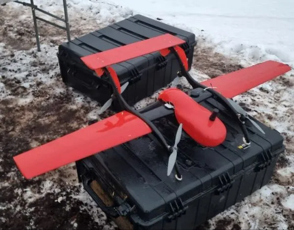
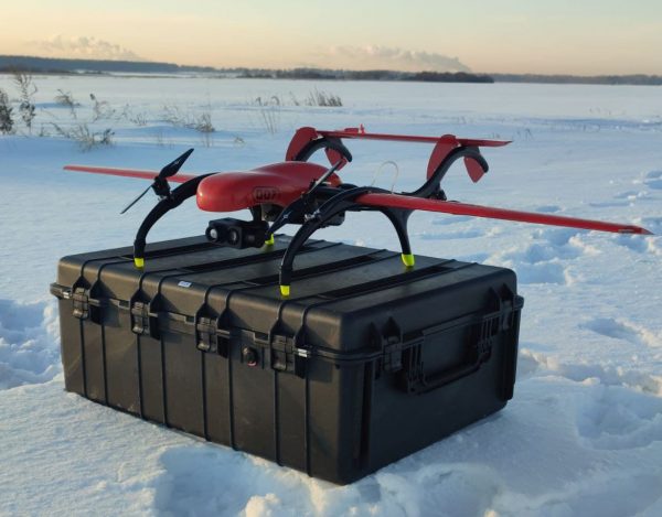
FIXAR 007 NG Laser Scanning drone is easy-to-use. Each FIXAR 007 NG fixed-wing VTOL drone is equipped with xGroundControl Software that can be installed on a laptop and used with Windows or macOS operating systems. Proprietary software is integrated with all FIXAR 007 NG UAV LiDAR units to make operation easy and intuitive for all users from novice to expert.
Wide Application
Laser scanning using autonomous drones is not just for specialty sectors. It has wide applicability across all industries including forestry, precision agriculture, monitoring of power lines, mining and aggregates, construction, archeology, and others.
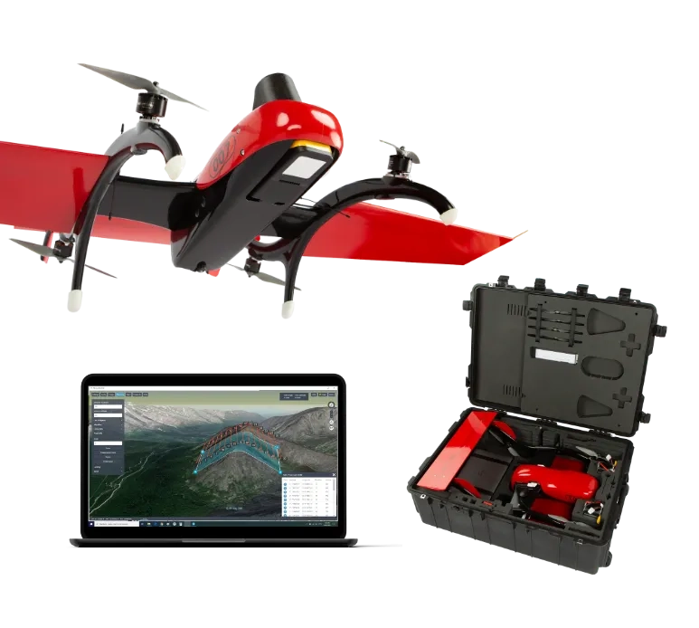
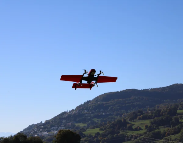
FIXAR 007 NG for Laser Scanning
With a reliable and robust design, high cargo capacity of 2 kg/ 4.4 lbs, and a large range of up to 30 km/ 18.6 mi (configured with LiDAR sensors) the VTOL UAV FIXAR 007 NG is ideal for efficient drone laser scanning.
Use your FIXAR 007 NG combined with LiDAR to capture and control information immediately. Use the data to inform decisions and create accurate 3D models and maps of any geographical terrain.
Learn MoreThe FIXAR 007 NG with LIDAR Sensor
Increased Safety
Reduce the risk in unstable environments such as nuclear and chemical fields. Safely survey and take accurate measurements from a distance.
Accurate Data Even in Sensitive Areas
Get data that’s accurate down to the finest detail. Scan sensitive areas without disturbing the environment using non-invasive technologies to obtain data.
Quality Data
Reduce errors, and the need for do-overs that result from collecting inaccurate data. Save money and time with increased accuracy.
Cost-Effective
Drone laser scanning can reduce overall project schedule times and costs. Accuracy minimizes waste and saves money and time.
Plug and Play Payload Modules Based on Real Job Tasks
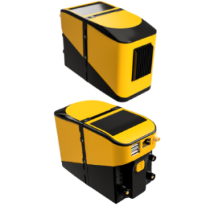
YellowScan Mapper+OEM
The YellowScan Mapper+OEM is equipped
Livox AVIA laser scanner together with
high-performance GNSS-aided
inertial navigation system into
a lightweight, standalone and
easy-to-use lidar system.
3 cm XYZ accuracy
Weight – 0.86 kg
Origin: France
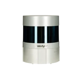
TOPODRONE LiDAR AVIA
LIDAR based on Livox Avia sensor
High-precision IMU with 0,08/0,03
degrees accuracy and L1/L2 GNSS receiver
3-5 cm XYZ accuracy
Weight – 0.8 kg
Origin: Switzerland
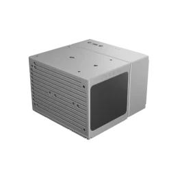
TOPODRONE LiDAR ULTRA
LIDAR based on Velodyne Ultra sensor
High-precision IMU with 0,08/0,03
degrees accuracy and L1/L2 GNSS receiver
3-5 cm XYZ accuracy
Weight – 1.1 kg
Origin: Switzerland
Plug and Play Payload Modules Based on Real Job Tasks
YellowScan Mapper+OEM
The YellowScan Mapper+OEM is equipped
Livox AVIA laser scanner together with
high-performance GNSS-aided
inertial navigation system into
a lightweight, standalone and
easy-to-use lidar system.
3 cm XYZ accuracy
Weight – 0.86 kg
Origin: France
TOPODRONE LiDAR AVIA
LIDAR based on Livox Avia sensor
High-precision IMU with 0,08/0,03
degrees accuracy and L1/L2 GNSS receiver
3-5 cm XYZ accuracy
Weight – 0.8 kg
Origin: Switzerland
TOPODRONE LiDAR ULTRA
LIDAR based on Velodyne Ultra sensor
High-precision IMU with 0,08/0,03
degrees accuracy and L1/L2 GNSS receiver
3-5 cm XYZ accuracy
Weight – 1.1 kg
Origin: Switzerland
Laser Scanning: Expanding Surveying Capabilities
Laser scanning using FIXAR 007 NG autonomous drones provides unparalleled detailed and accurate data. Using this system will increase the quality, safety, and sustainability of your organization.
Are you ready to start using FIXAR 007 NG Laser Scanning in your organization?


High Quality Outputs from Every Single Mission
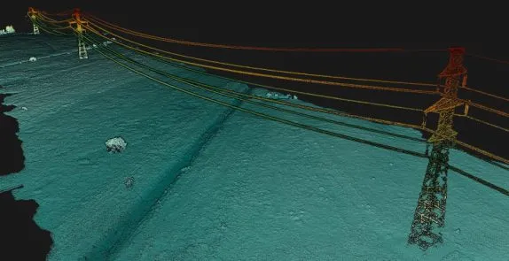
3D point cloud
3D point cloud of powerlines collected with YellowScan Mapper+OEM. Processed with YellowScan CloudStation
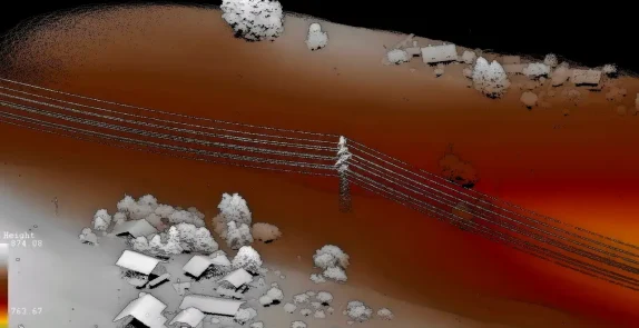
3D Point cloud
LIDAR point cloud captured with TOPODRONE LIDAR laser scanner
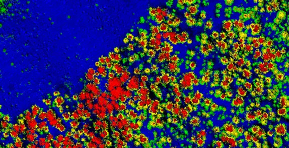
3D point cloud
Point cloud of a road section with forested areas on both sides of the road
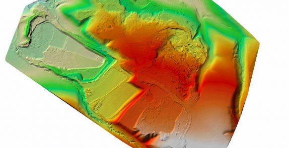
Digital elevation model (DEM)
Digital elevation model of a mining site
3D point cloud
3D point cloud of powerlines collected with YellowScan Mapper+OEM. Processed with YellowScan CloudStation
3D Point cloud
LIDAR point cloud captured with TOPODRONE LIDAR laser scanner
3D point cloud
Point cloud of a road section with forested areas on both sides of the road
Digital elevation model (DEM)
Digital elevation model of a mining site
Case Studies
Explore Other Solutions
We pair our drones with our proprietary software operating systems and controls to deliver all-in-one elegant UAV solutions, revolutionizing how technology is being used in various industries worldwide, including agriculture, oil & gas, construction & civil engineering, mining, surveying, photogrammetry, cartography and more.