Geomagnetic resistance for safe flights in mountains
Mountainous areas are highly complex environment to execute missions with remotely piloted aerial systems. Thinned air, difficult terrain, harsh and changing weather conditions increase the difficulty level of flights. In mountainous areas, geomagnetic anomalies can interfere with drone operations and even compromise the entire mission.
When looking at challenging locations for aerial missions, the drone operators are commonly aware of the risks and limits, yet some get missed out.
This time we look more closely at the geomagnetic resistance, as often this feature gets overlooked, and it is clear why – in daily operations, drone operators do not face magnetic anomalies as an obstacle too often. Also, this anomaly is not so obvious if compared to other factors, let’s say strong wind, fog, rain, or snowfall. The anomalies can be detected, but not felt as they are not visible.
What are magnetic anomalies?
Magnetic anomalies are defined as the deviation of the observed quantities, i.e., gravitational acceleration and magnetic flux density, respectively, from the expected value of reference in Earth (ref. Science Direct). Simply put, magnetic anomalies are the change in magnitude of the Earth’s magnetic field with respect to the expected value for that location. So, – deviation from estimates for the area.
Magnetic anomalies are common in mountainous areas, but magnetization and interference with the drone operations can also occur close to large size metallic structures. Therefore, geomagnetic resistance can protect the drone in several different settings than just mountains.
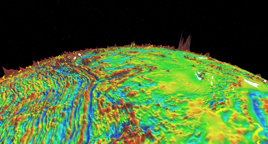
EMAG2: Earth Magnetic Anomaly Grid | Image courtesy of BGR, GeoMag
Why is geomagnetic resistance important?
It is estimated that up to 80% of multirotor drones malfunction by wrong data provided through the magnetometric sensor. In order to prevent these situations during the pre-flight procedures, a so-called compass calibration is required. Moreover, the magnetometric sensor does not allow multirotor drones to work properly near metal objects and in mountainous areas. Usually, manual control is selected and by doing so it may result in a loss of control of the aircraft or even a crash.
One of the extraordinary features of FIXAR 007 is the geomagnetic resistance. With proprietary navigation autopilot algorithms and with no magnetometric sensors used, FIXAR simplifies the use of its drones, saves preparation time, eliminates potential problems and there is no need for calibration.
We have tested FIXAR 007 operation ability at high altitudes at Europe’s highest mountain – Elbrus exceeding an altitude of 4 000 m (13 123 ft). FIXAR 007 performed and captured required data to develop a model of cable car infrastructure. In this specific case FIXAR 007 was chosen, as a copter drone failed to operate at this altitude. The fixed-wing VTOL solution was chosen as a suitable solution for the mission.
How to check if the drone is mountain-ready?
The mountains will definitely challenge the operation, so the best approach to avoid additional costs and risk of damages is to check the UAV before departure to the mission location.
Always check the manufacturer’s manual and technical data sheet of the UAV to evaluate if it is applicable for high-altitude flights.
- Check if the UAV contains magnetometric sensor – if the drone has one, it is not recommended to use it for high altitude operations above 3 500 m (11 482 ft);
- Check what is the altitude limit for the UAV and compare it to the mission area altitude – if altitude is exceeded, do not use the UAV.
- Check if the UAV has a built-in altitude limit. If it is set, it is usually 120m (400ft) meaning that the UAV will not be able to climb higher than that measured against the altitude of the takeoff location.
What else to consider for a mission in the mountains?
- Estimate greater batteries consumption caused by lower air density and temperature – bring an additional set of batteries;
- Study wind patterns – consider wind currents near the cliffs, in the valleys, etc.
- Check the weather forecast – avoid flights in strong wind conditions. Prepare and be ready for rapid weather changes.