All you need to know: Geofences and Public Zones
Stepping into the world of unmanned aerial systems you most likely will hear terms like restricted areas, geofences and geofence systems, no-fly zones and related. All these terms are relevant when planning and executing safe aerial missions, to avoid areas that are off limits or require special permissions to fly over such restricted areas, as well as areas that the operator intends to avoid based on other factors or reasons.
What is a geofence?
In a broader general sense, geofence is a virtual boundary for a physical geographic location. Geo-fencing is a feature in the software that uses radio frequency identification (RFID), Wi-Fi, GPS, or cellular data to define geographical boundaries. The functionality of the geofencing system allows to read the location of an object and trigger certain actions when an object enters the virtual perimeter.
In the drone industry, geofences refer to the areas that are open for UAV missions or limited zones that require special permits. If a drone is approaching and entering a geofenced perimeter, the operator receives a push notification, alert, or instruction about limitations to access the zone in question.
Geofencing is not only used by UAV operations, it is commonly used in law enforcement, human resource management, home automation, marketing, and other industries. In daily life, it is a common situation to receive text messages on your mobile phone when entering a certain area, such as when the mobile data operator applies different charges, for instance, crossing a country border. Similar notices are often received when approaching a country border zone or approaching military restricted areas, or simply going past a store and receiving notification about special offers.
What role do the geofences and public zones play in the drone industry?
Public zones are considered areas that hold limitations due to infrastructure objects such as airports, airfields, or due to other high-security areas such as a country border or natural protected areas such as preservation, a natural park or a bird nesting area. Geofences and public restricted zones can be applied for a period of time. For instance, a political or economic conflict in the area, a periodical or temporary restriction in certain seasons, etc. Not all public zones have push notifications in place, therefore limited zone requirements must be checked beforehand.
For drone operators, it is relevant to investigate limited areas at the location where flights are planned to take place and avoid any areas that are limited or apply for a permit at the local civil aviation authority.
Several software solutions for drone mission planning already offer zone area markings for operators to easily avoid perimeters with restrictions.
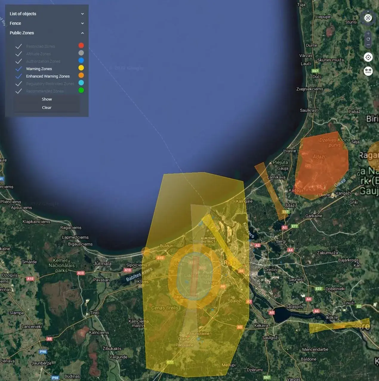
Map with warning and restriction zones – FIXAR xGroundControl software
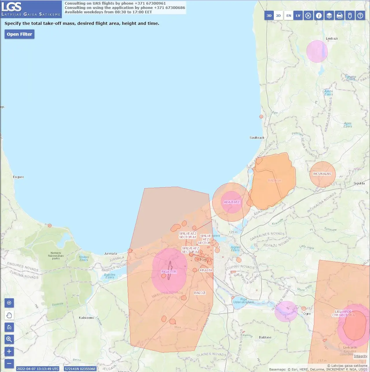
Map with warning and restriction zones – Air Traffic Control Centre of Latvia airspace map
Map with warning and restriction zones – FIXAR xGroundControl software
Map with warning and restriction zones – Air Traffic Control Centre of Latvia airspace map
If mission planning software does not have an extension with defined restricted airspace zones, the operator can always check for available area maps that mostly are provided by the National Airspace Authorities. As in the images above, you can see that both maps are almost equivalent and serve as reliable guidance in the planning process.
The most convenient way is to have zones available in your planning software. Before, during or after building the mission plan the operator can turn on a preview of the zones to clearly identify if any flight route conflicts with the restricted zone. In the event that a conflict appears, the operator shall adjust the flight route and can safely launch the mission. There are some drone models with integrated no-fly zones, meaning that drone technically and practically is not able to enter no-fly zones. The operator can find this information in the product manual or technical data sheet.

Marked survey area and yellow public area – FIXAR xGroundControl software
Can you build your own fence?
Some software solutions are advanced enough that they allow operators to set a no-fly area by themselves. The idea behind it is that in this case, the area is not prohibited or restricted by the National Authorities, rather than areas that the operator wants to avoid based on other reasons or specific needs.
When to apply this feature? In many cases, missions may cross areas like waterways or take place near private property. To avoid entering areas with potential risks, the operator can draw their own Geofence around the object or area to avoid. In the example, you see that when planning a mission, the system prohibits placing mission routes or points in this area and alerts the operator about it. Not all software platforms offer such a function though. If you find it relevant, always check the software manual or description before investing in the purchase of the UAV system.
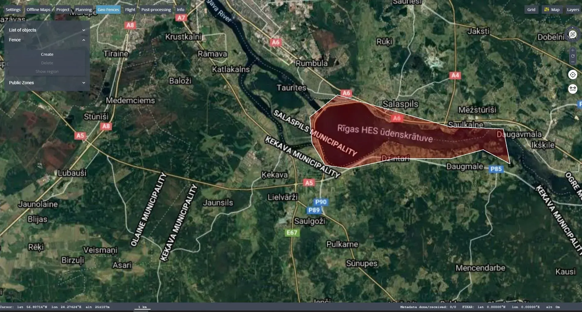
Map with no-fly fence built by operator – FIXAR xGroundControl software
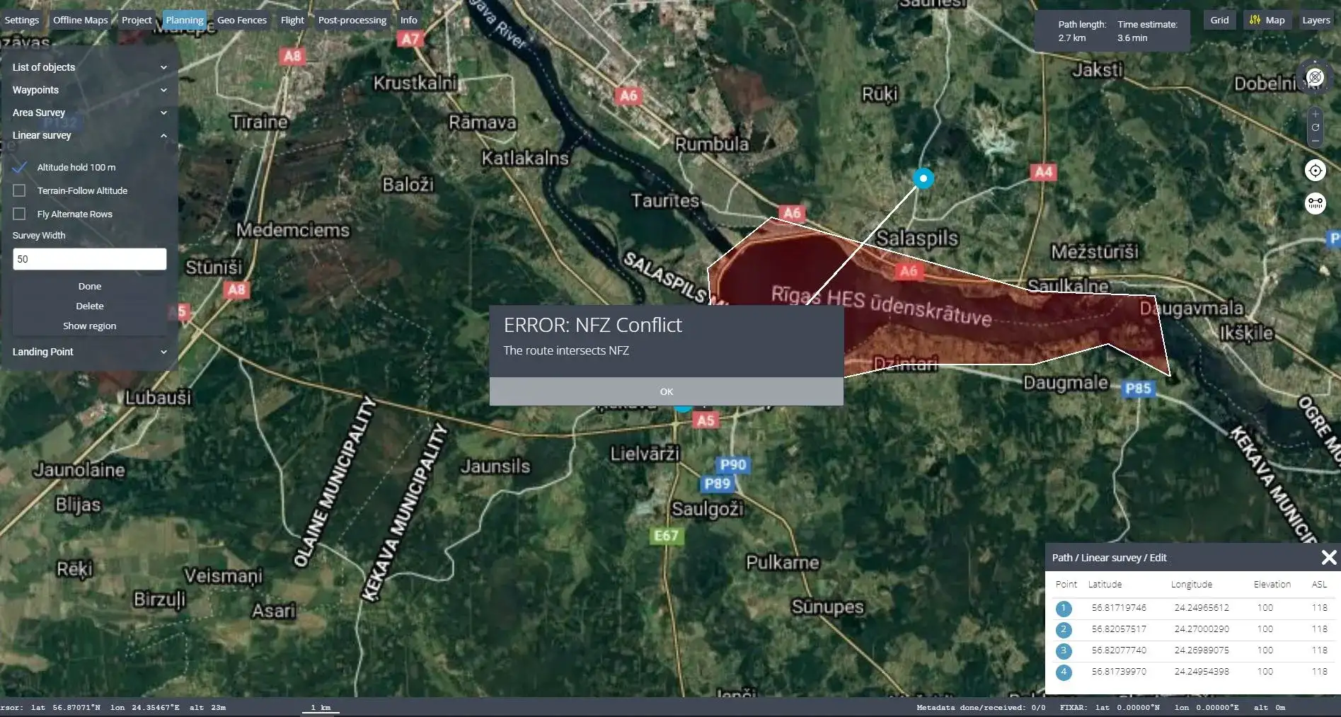
The ERROR alert stating that mission plan conflicts with fenced area – FIXAR xGroundControl software
Map with no-fly fence built by operator – FIXAR xGroundControl software
The ERROR alert stating that mission plan conflicts with fenced area – FIXAR xGroundControl software
What is the difference between a public zone and a self-built fence?
The public zones are regulated by Aviation Authorities, meanwhile, self-built geofence to restrict certain areas is a choice of the drone operator based on surrounding objects, location and other aspects.
The public zones usually do not interfere with drone operations, except in cases when the drone is set up by the manufacturer to respond to limitations and restrict them to enter certain level public zones. In most cases, the drone is able to enter public zones.
The self-build fence is different in its functions, – it denies any mission waypoints to be placed in the fenced area. In this case, a drone cannot enter the area, nor mission can be planned in the zone.
“It is highly important to follow the regulations and not risk your pilot license, therefore I always check for restricted or no-fly zones before any flight. It is recommended to check it once again right before the flight starts, in case some more restrictions have appeared. In this case, you might need to change something in your pre-planned mission or even do the flight elsewhere.
There are different web pages from which you can check these zones, but they are different for each country. It is a lot easier if the ground control software has it already integrated and has the same restrictions as the public maps, instead of trying to find the official web pages, which are also designed differently for each country. It is important for me to be able to create a geofence myself, for example, I’m doing a mission in a field, but there is a house that I should not fly over. Then I can add the fence and not “bother the neighbors” with my flights,”
Karina Limora, Senior Demo Engineer at FIXAR.
Get to know FIXAR xGroundControl Software and learn how to use the geofence feature in the webinar session with Karina Limora, Senior Demo Engineer.